
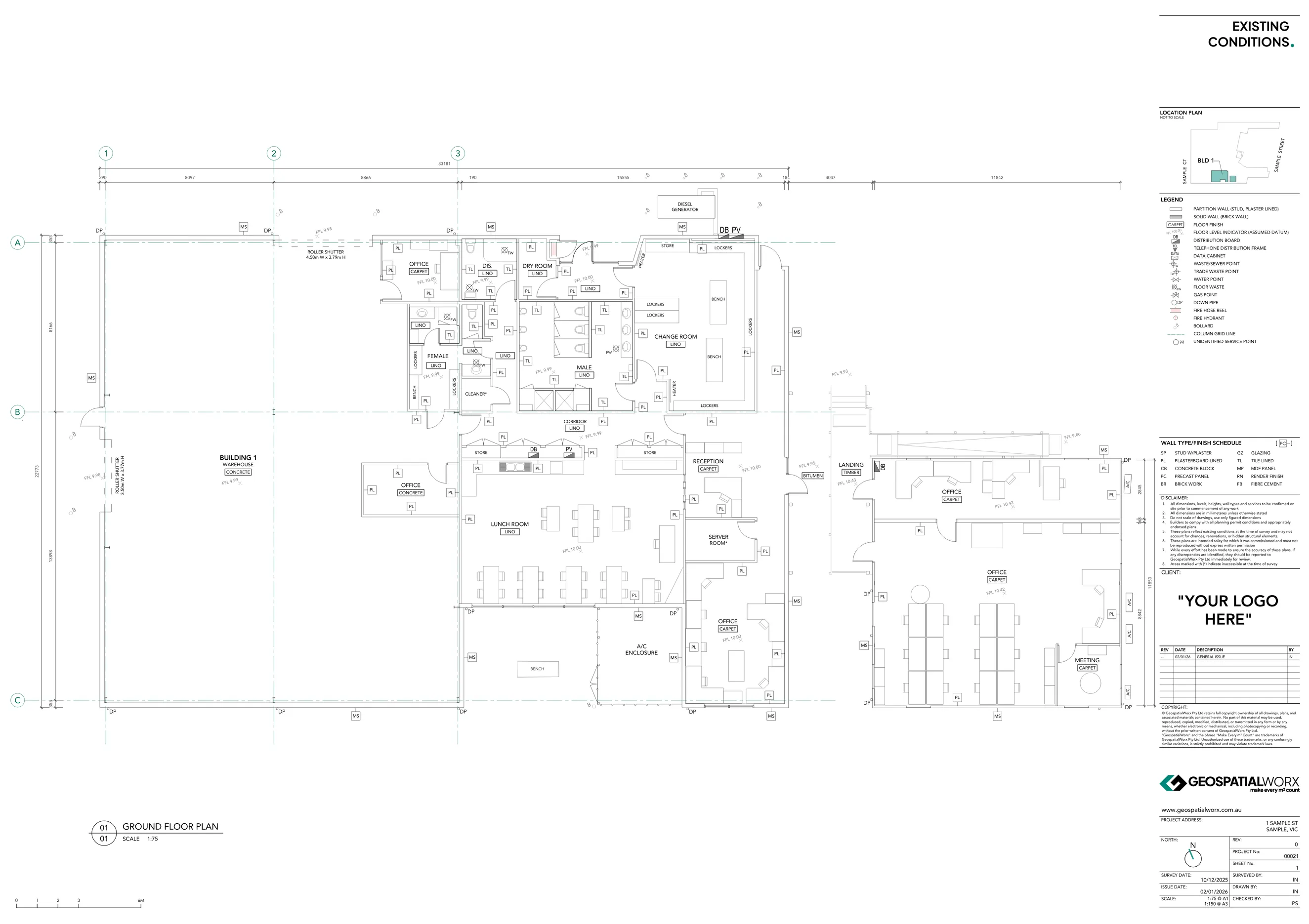
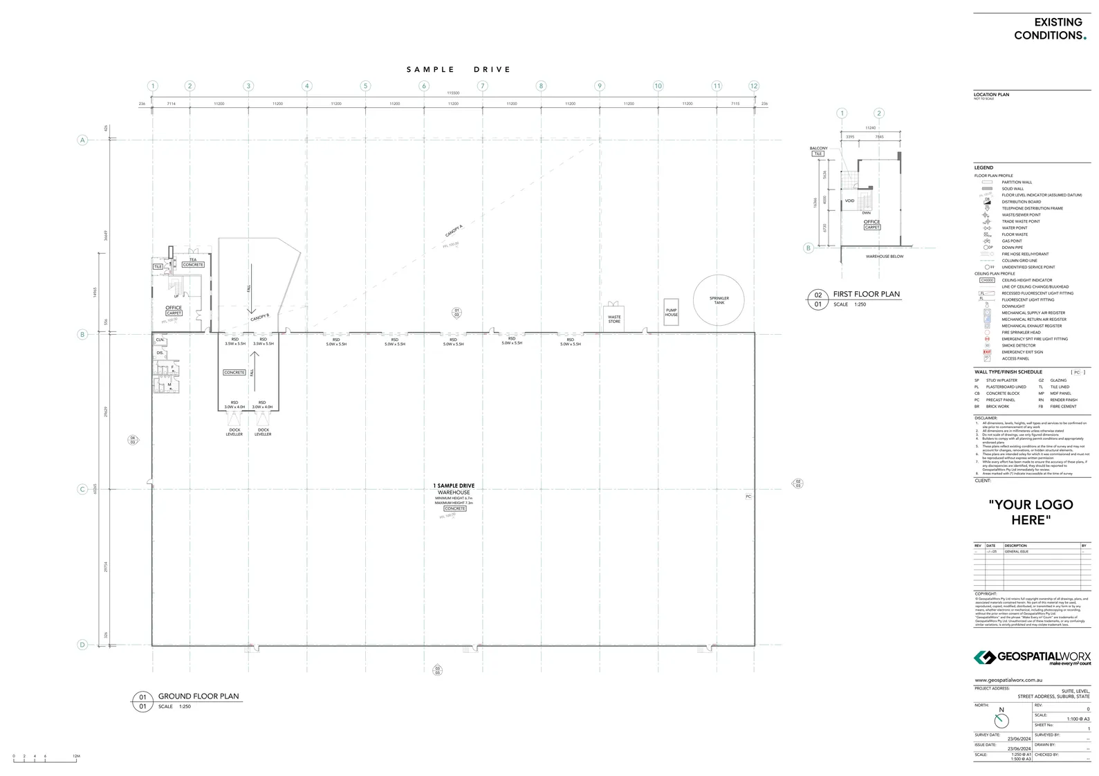
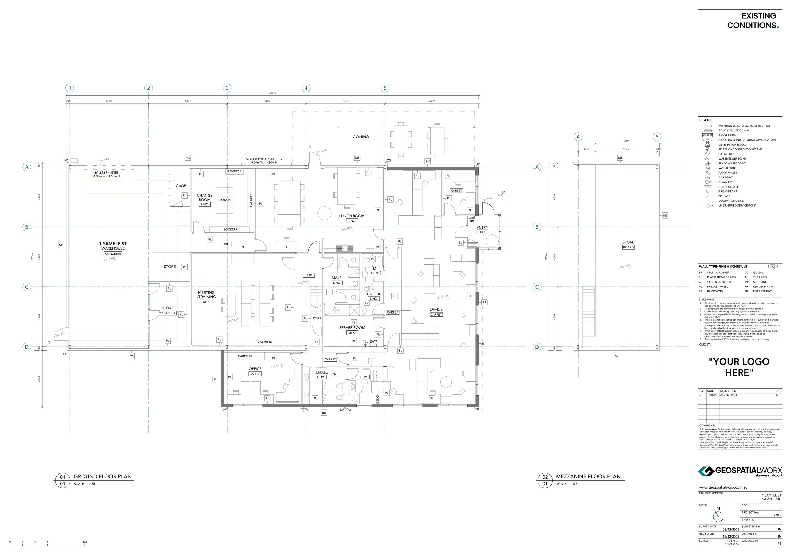
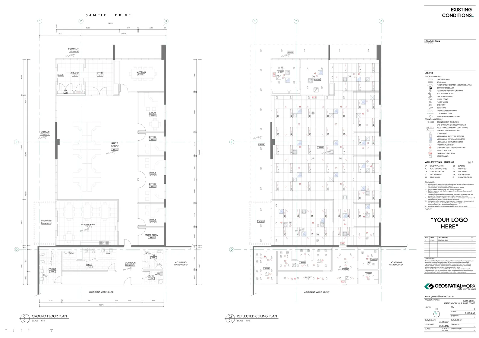
Existing Conditions Plans aka As-Built Plans
Our Existing Conditions Plans provide an accurate record of the built form in plan view — including detailed dimensions, wall types and services. The reliable base for any design & fitout work.
Made for Design and Fitout

Get Your Existing Conditions Plan Today
Reach out to the team directly and we’re happy to help.
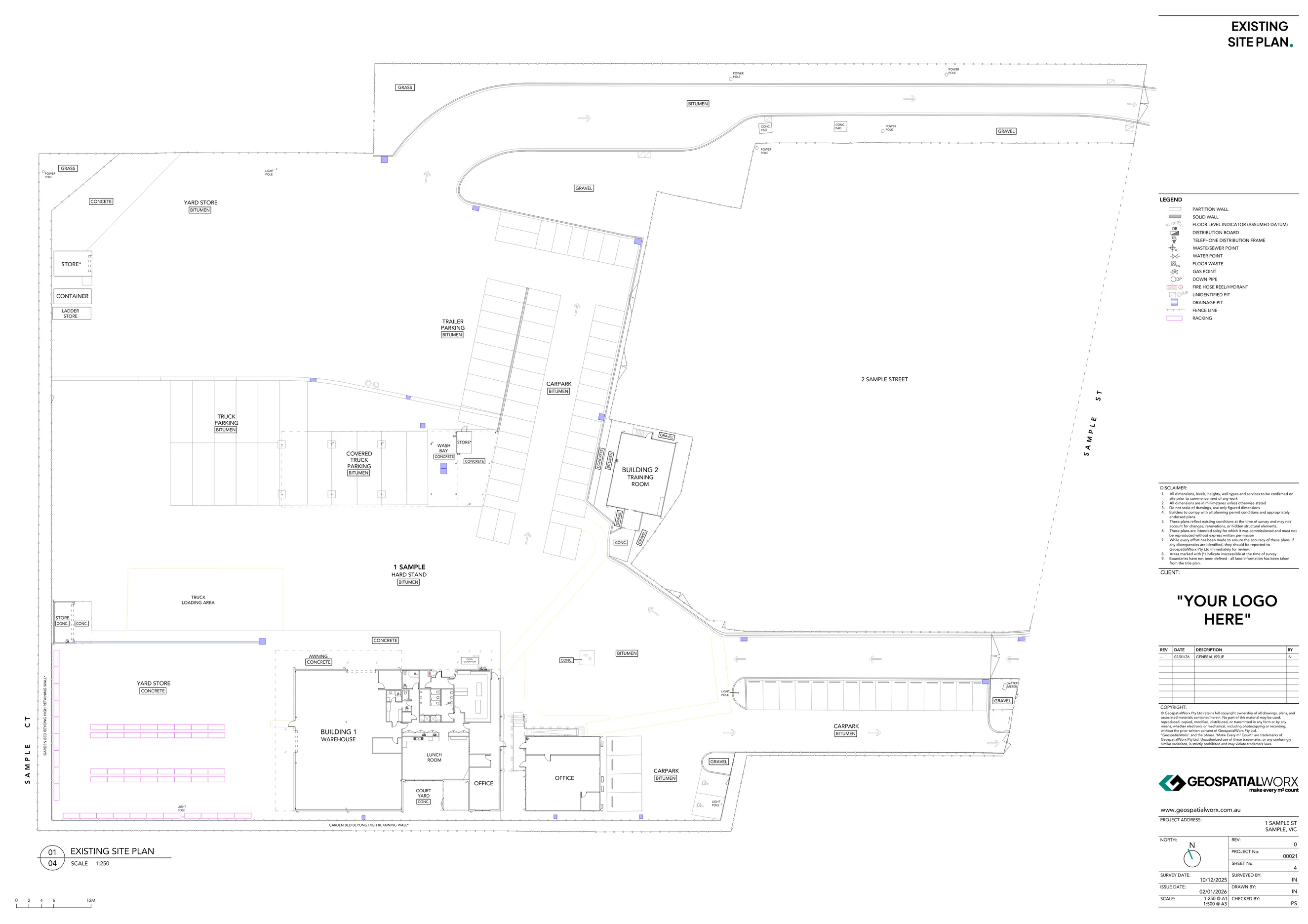
Existing Conditions Floor Plans - The Verified Base For All Design & Fitout Needs
At GeospatialWorx, we produce Existing Conditions and As-Built Plans that accurately represent a building’s current form and layout.
Using 3D laser scanning and survey-grade instruments, we deliver precise documentation that forms the foundation for design, fitout, and renovation projects — helping you make informed decisions with verified data.
What Are Existing Conditions Floor Plans/ As-Built Plans?
A measured 2D plan that documents the real-world layout of a building - not design intent. It shows:
- Base building walls, cores, columns and grids
- Internal partitions and room layouts
- Wall types
- Doors, windows, stairs, lifts and risers
- Amenities & service rooms
- Fixtures
- Floor finished and levels
- Ceiliing heights
- Dimensions
Why Use Existing Conditions Surveys?
- Accurate Design Base – Avoid guesswork and design errors with verified geometry.
- Time and Cost Efficiency – Reduce rework and clash detection issues during construction.
- Design Coordination – Provide consistent data to architects, engineers, and consultants.
- Regulatory Compliance – Document existing conditions for approvals, permits, or audits.
- End-to-End Integration – Deliverables compatible with CAD and BIM environments.
Our Process
1. Site Scanning
We use Leica 3D laser scanners and total stations to capture complete site geometry and existing conditions.
2. Data Registration
Collected scans and survey data is registered into a single, unified point cloud, ensuring spatial accuracy across all areas and levels.
3. Drafting
We produce the required 2D drawings from the point cloud using BricsCAD, tailored to your project’s required level of detail.
4. Quality Assurance
Each plan is reviewed for alignment, accuracy, and presentation quality before release.
5. Delivery
Final deliverables are supplied in PDF & DWG, ready for immediate integration into design and documentation workflows.
Made for
- Architects and Designers – Develop renovation or fitout designs on verified building data.
- Engineers and Consultants – Plan upgrades and retrofits with confidence.
- Builders and Contractors – Validate on-site works against existing drawings.
- Asset and Facility Managers – Maintain accurate as-built documentation for compliance and maintenance.
Technology We Use
- Leica 3D Laser Scanners
- Topcon Total Stations
- Leica Cyclone REGISTER 360
- BricsCAD
Deliverables Available
- CAD dwg
- Optional: Revit
- Optional: Point Cloud Files (.RCP / .E57)
GeospatialWorx delivers as-built and existing conditions documentation with accuracy, consistency, and speed — ensuring your next design or fitout project starts with complete confidence in every m².
Get Your Existing Conditions Plan Today
Reach out to the team directly and we’re happy to help.
Frequently Asked Questions
Do you include ceiling heights and FFLs?
Yes—key heights and FFL/RL can be added where needed. We’ll scope exactly what you want shown.
Can floor levels be set to an Australian Height Datumn (AHD)?
Yes if required we can set all our levels to an Australian Height Datum. If not required they will be set to an arbrtriary datum.
Can you show furniture and racking?
By default we document base building and partitions. Furniture and racking can be added as an optional layer.
Can you survey while the building is occupied?
Yes, we routinely work in live environments and have developed efficient means of data capture next to no disruption.
Do you document wall types and finishes?
Yes, when known we will document walls types and finishes. Concealed wall structures not possible with current technologies.
What are your CAD layering systems like?
As a standard we have a robust and easy to understand layering system.
Are service points be included in the scope?
By default we document the following service points if available: Distribution boards, TDF, floor & trade waste points, fire hose reels & hydrants. For any services outside this list we can add them in as an optional layer.
Compliant
Experience
Experience
Expertise