
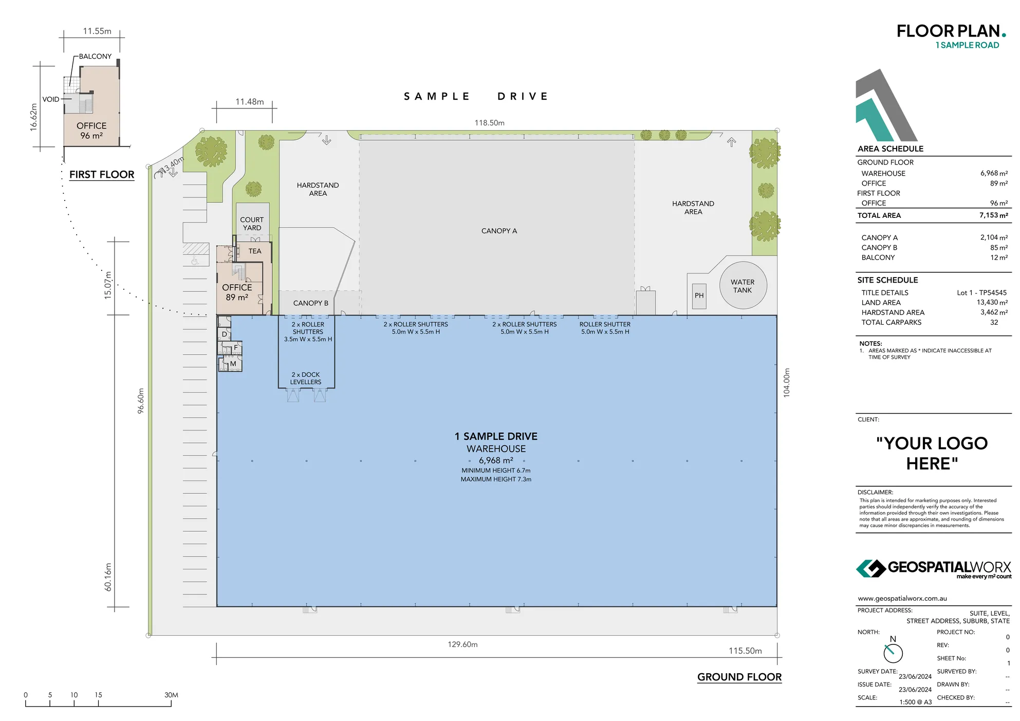
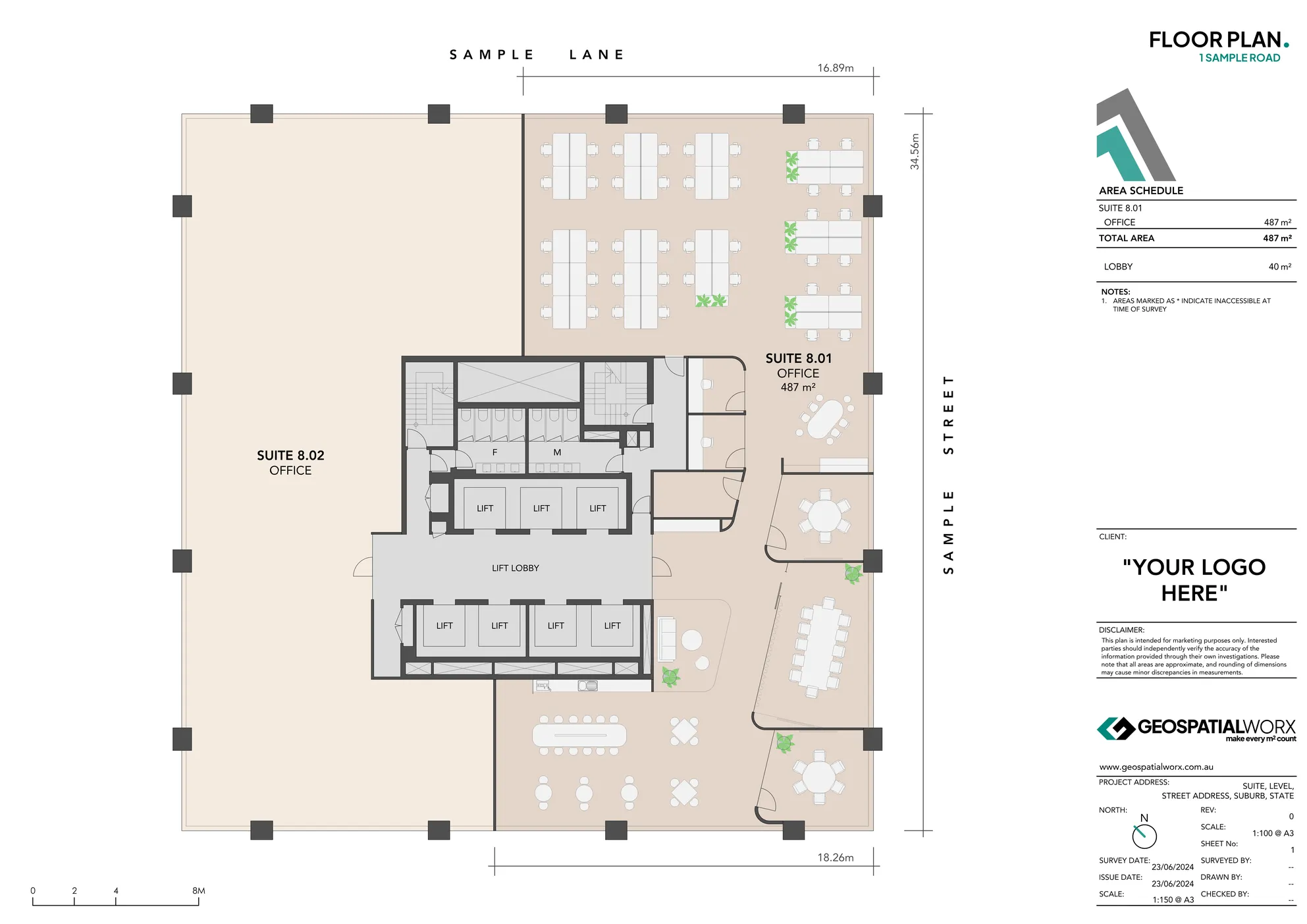
Floor Plans & Site Plans
Styled plans that communicate layout and flow. Designed to look great in brochures, IMs, listings and stake holder packs. Suitable for all property types.
Made for Marketing/Asset Management

Available Options
Floor Plans
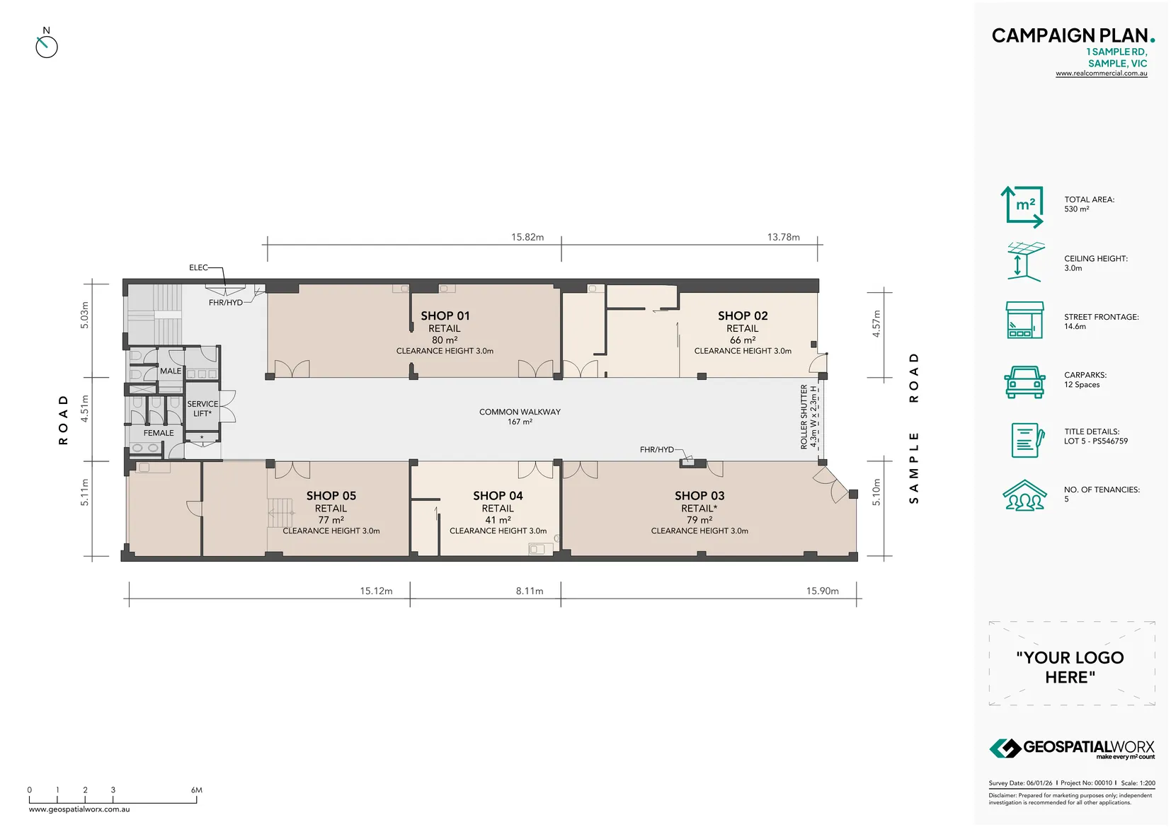
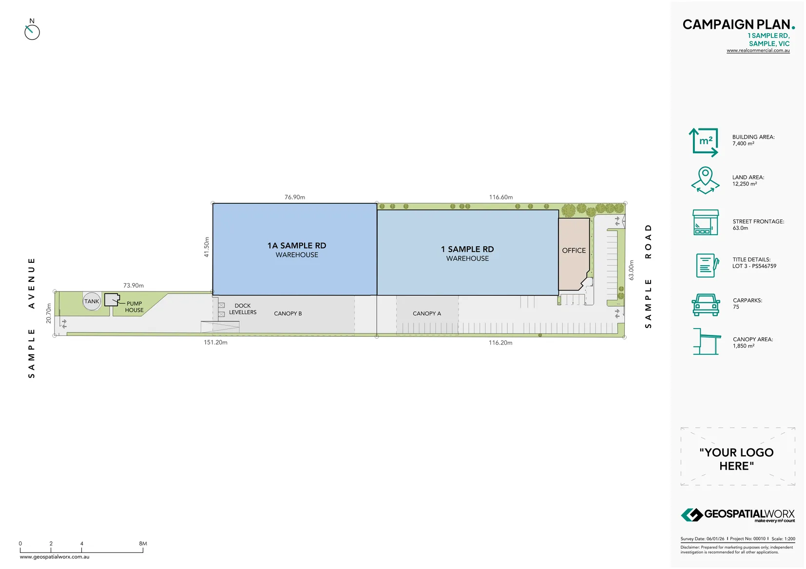
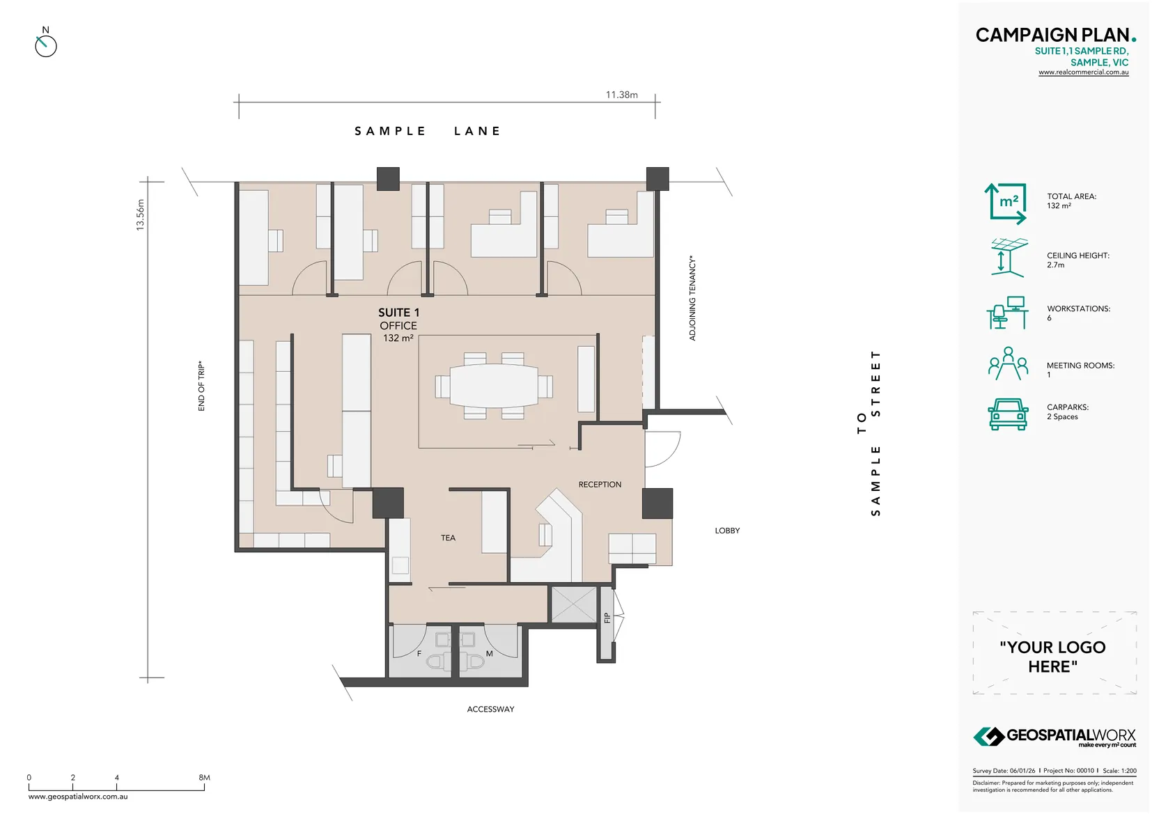
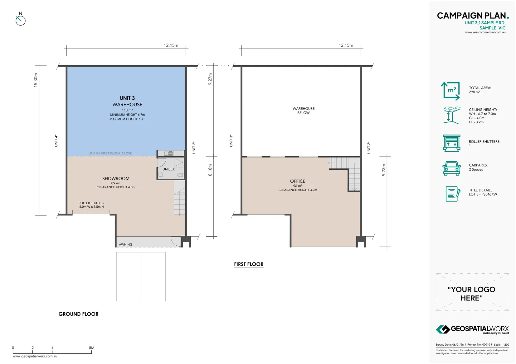
Campaign Plans
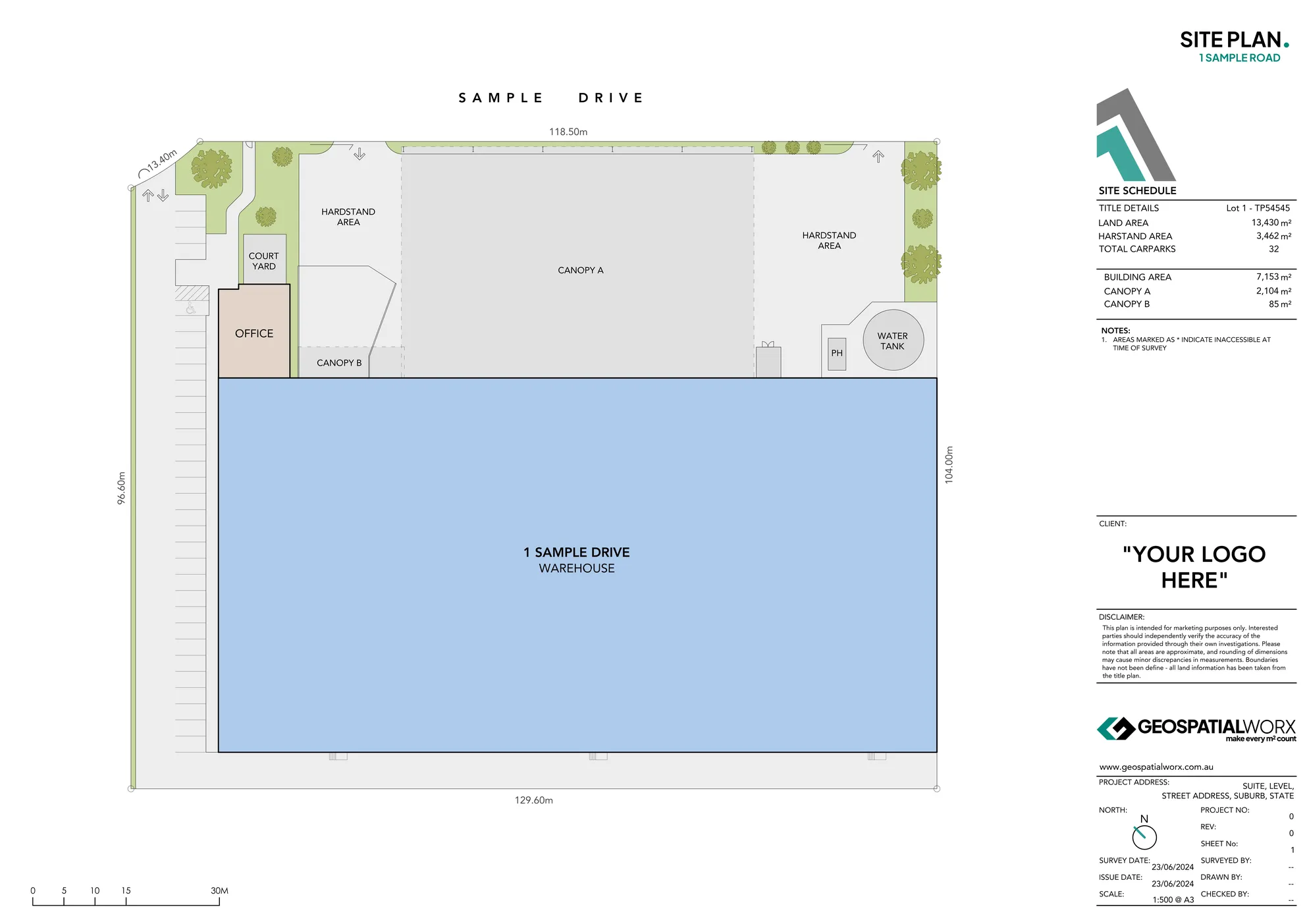
Site Plans
Need a Floor Plan That Speaks for Itself?
Reach out to the team directly and we’re happy to help.
Understanding Our Product Features
To help you choose the right product for your project, here is a breakdown of why specific technical features are included or excluded based on your goals:
- Survey-Grade Accuracy: Unlike generic sketches or "artist impressions," every GeospatialWorx plan is built on high-precision 3D laser scanning data. This ensures that even a marketing-focused "Campaign Series" plan is a mathematically correct representation of the asset.
- Service Points (Elec/Comms/Hyd): This level of detail identifies the exact location of power, data, and plumbing connections. While unnecessary for a marketing brochure, it is critical for Existing Conditions surveys to help architects and engineers plan fitouts without needing costly site revisits.
- Digital Listing Link: Found exclusively in our Campaign Series, this feature transforms a static PDF into a live marketing tool. It provides a frictionless path for potential tenants or buyers to jump straight from the plan to the online listing or social media content.
- Wall Types (Structural vs. Partition): For Existing Conditions, we distinguish between load-bearing structural walls and lightweight partitions. This is essential for design and fitout phases but is simplified in Floor Plans & plans to keep the visual focus on spatial flow and marketing cues.Campaign Series
- PCA 2008 Compliance: This is a specific legal requirement for commercial leasing in Australia. While other plans are accurate, only the PCA Survey is certified under the PCA Method of Measurement (2008) for inclusion in formal lease contracts and asset reporting.
- Marketing Iconography: These high-impact visual cues—such as Workstation capacity, Roller Shutters, and Ceiling Heights—are designed to answer an agent's or buyer's most pressing questions at a single glance.
1. Campaign Floor Plans
Made for Marketing Impact
Our Campaign Plans transform technical survey data into a high-impact visual sales tool. Engineered specifically for web listings, Information Memorandums (IMs), and social media, this series strips away technical clutter to prioritize buyer engagement and rapid information delivery.
- Integrated Connectivity: Features a direct, interactive listing link to bridge the gap between the PDF plan and your online campaign.
- Visual Cues: Utilizes a specialized suite of icons to highlight key metrics like workstation counts, internal clearance, and car parking at a glance.
- Survey-Grade Foundation: While optimized for marketing, every plan is built with the same precision 3D laser scanning accuracy as our technical documents.
Best for: Real estate agents, asset managers, and landlords looking to drive higher click-through rates and faster inquiries.
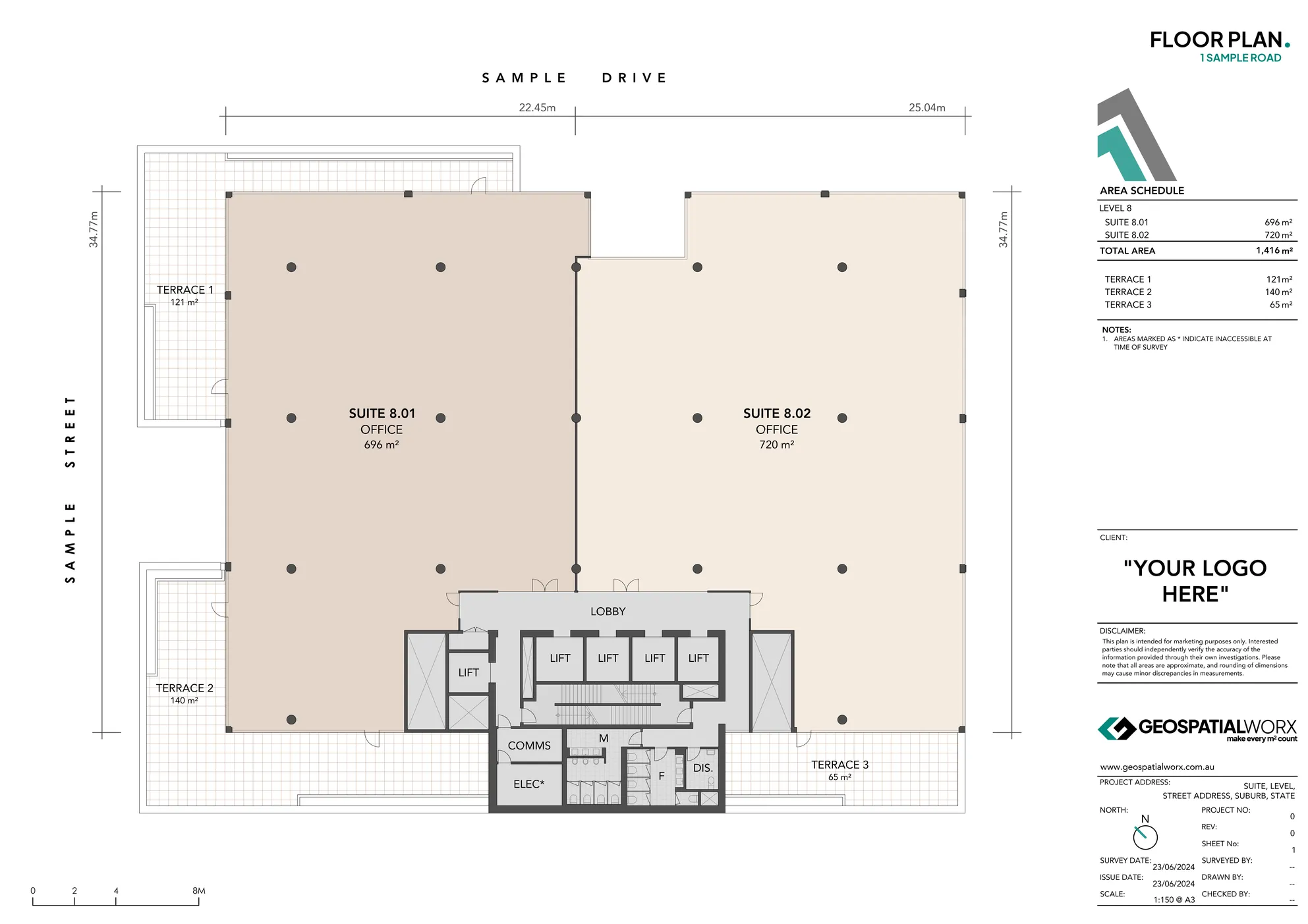
2. Standard Floor Plans
The Essential Multi-Purpose Asset
Our Standard Floor Plans provide a clear, detailed, and accurate representation of your property for general reference and internal reporting. They serve as the foundational document for property managers and owners who need a reliable "source of truth" for their assets.
- Comprehensive Layout: Includes standard architectural notations for walls, doors, windows, and core building features.
- Technical Clarity: Features full title blocks, area schedules, and precise dimensions for all internal spaces.
- Scalable Detail: Provides enough information for general planning and web display without the complexity of a design-grade survey.
Best for: Property managers, owners, and facilities teams requiring a clean, professional record of their building's layout.
3. PCA Surveys (Leasing)
The Gold Standard for Compliance
When it comes to lease contracts and asset reporting, precision is a legal requirement. Our PCA Surveys are prepared in strict accordance with the PCA Method of Measurement (2008), ensuring complete transparency and compliance for all stakeholders.
- Methodology Experts: Specialized in NLA, GLA, and GLAR plans to ensure your lease areas are calculated correctly to maximize yield.
- Digital-Ready Outputs: We deliver digital-ready plans that integrate seamlessly into your asset management and reporting systems.
- Compliance Certainty: Reduce contractual disputes by providing certified plans that meet ANZVPS and industry standards.
Best for: Landlords, leasing agents, and asset managers who need certified accuracy for commercial, industrial, or retail lease agreements.
4. Existing Conditions Plans/Surveys
Precision Data for Design & Fitout
The Existing Conditions series is our most technically robust product, designed to eliminate the "site measure" time for architects and engineers. By leveraging high-precision 3D laser scanning, we provide a digital twin of your building's current state.
- Technical Depth: Includes detailed structural wall types, service points (electrical, hydraulic, comms), and reflected ceiling plans (RCP).
- BIM & CAD Ready: Delivered in layered PDF, DWG, or 3D Revit models to provide an immediate base for your design team.
- Reduced Risk: Identify structural discrepancies and service clashes early in the pre-contract phase to avoid costly on-site variations.
Best for: Architects, interior designers, engineers, and fitout contractors who need exact "as-built" data before starting a project.
Need a Floor Plan That Speaks for Itself?
Reach out to the team directly and we’re happy to help.
Frequently Asked Questions
Are area schedules included with the plans?
Yes a schedule of areas will accompany any floor and site plans. Building areas are typically broken down dependent on use of space; rehouse, office, retail, amenities, service areas, etc.
What is included in a Floor Plan?
A scaled plan showing the base building (external walls, columns, structural cores), interior layout (partitions, rooms, amenities), access & circulation (entries, doors, windows, stairs/lifts), and labels/dimensions for key spaces. Industrial plans also note clearances, roller shutters, dock levellers, awnings/canopies. Each sheet includes north point, scale bar, title block, and an area schedule.
What's the difference between a floor plan for marketing and a PCA survey?
Our Floor Plans for marketing are styled for clarity and presentation. Items such as lease line nominations and symbols typically found on a PCA Survey are not required on a floor plan and often clutter and distract upon the visual appeal of a Floor Plan prepared for marketing.
What is a typical turnaround for this product?
Single sites/tenancies: 4-5 business days. Multi-level or large sites: 7-10 business days. Express options available.
Are revisions included?
Yes, edits within scope are included free of charge.
Can you include workstations or racking layouts?
Yes, office workstations and warehouse racking can be added in as additional scope items.
Can you restyle our legacy CAD/PDFs without a site visit?
Yes—our Desktop Floor Plans service restyles and standardises your existing drawings for presentation. Accuracy mirrors your source; we would suggest a measured survey if you need verification.
Compliant
Experience
Experience
Expertise