
PCA Surveys
Lease-grade area documentation measured to the Property Council of Australia's (PCA) Method of Measurement 2008 - clear, defensible areas for fast, low-friction leasing.
Made for Leasing

Available Options
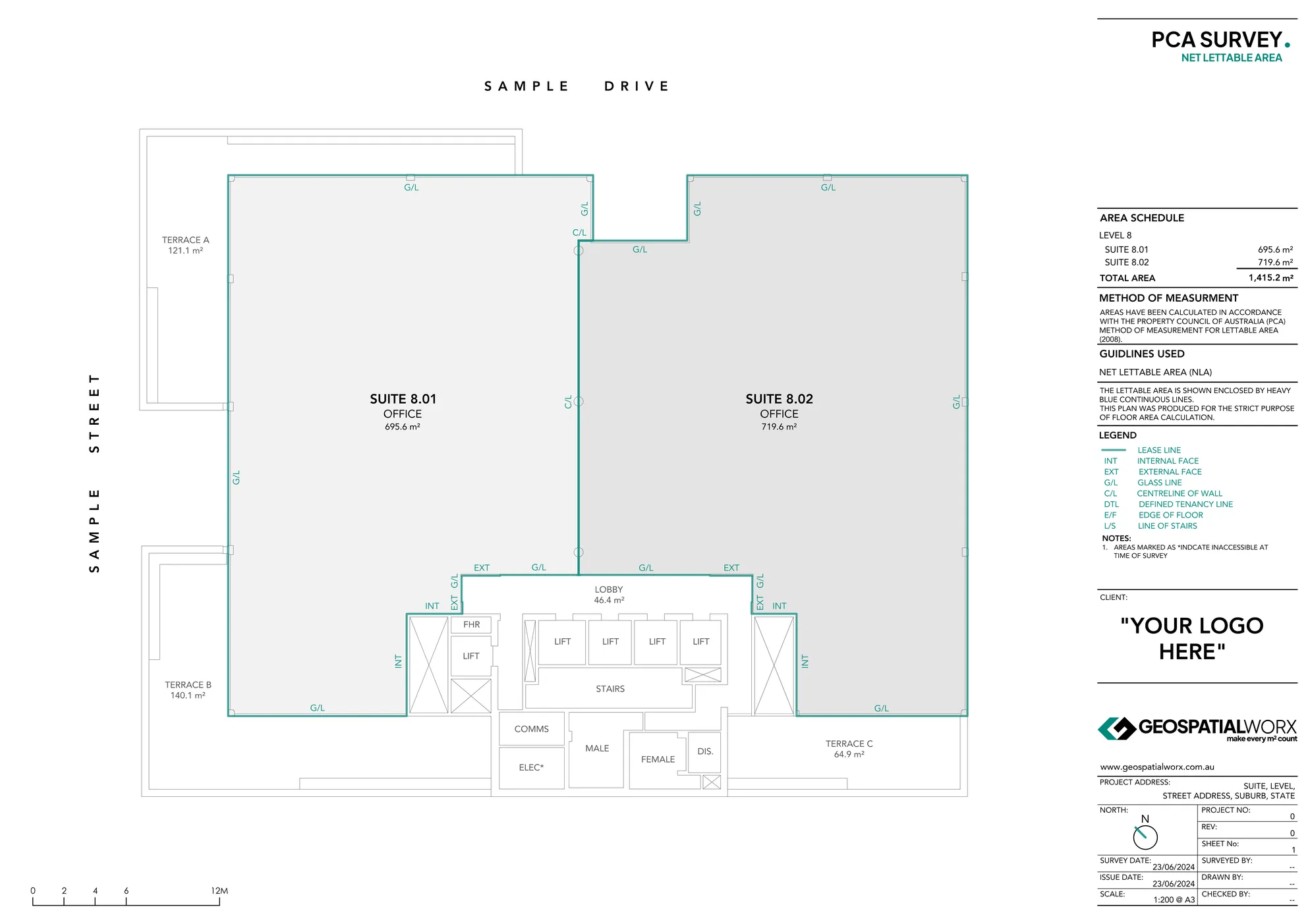
Net Lettable Area Survey (NLA)
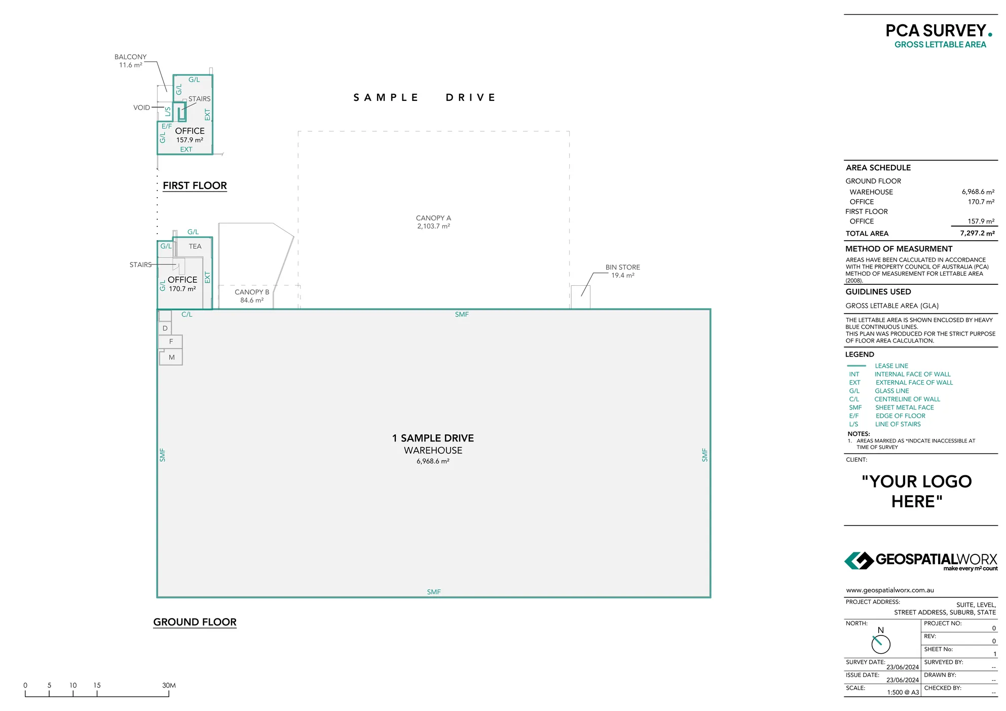
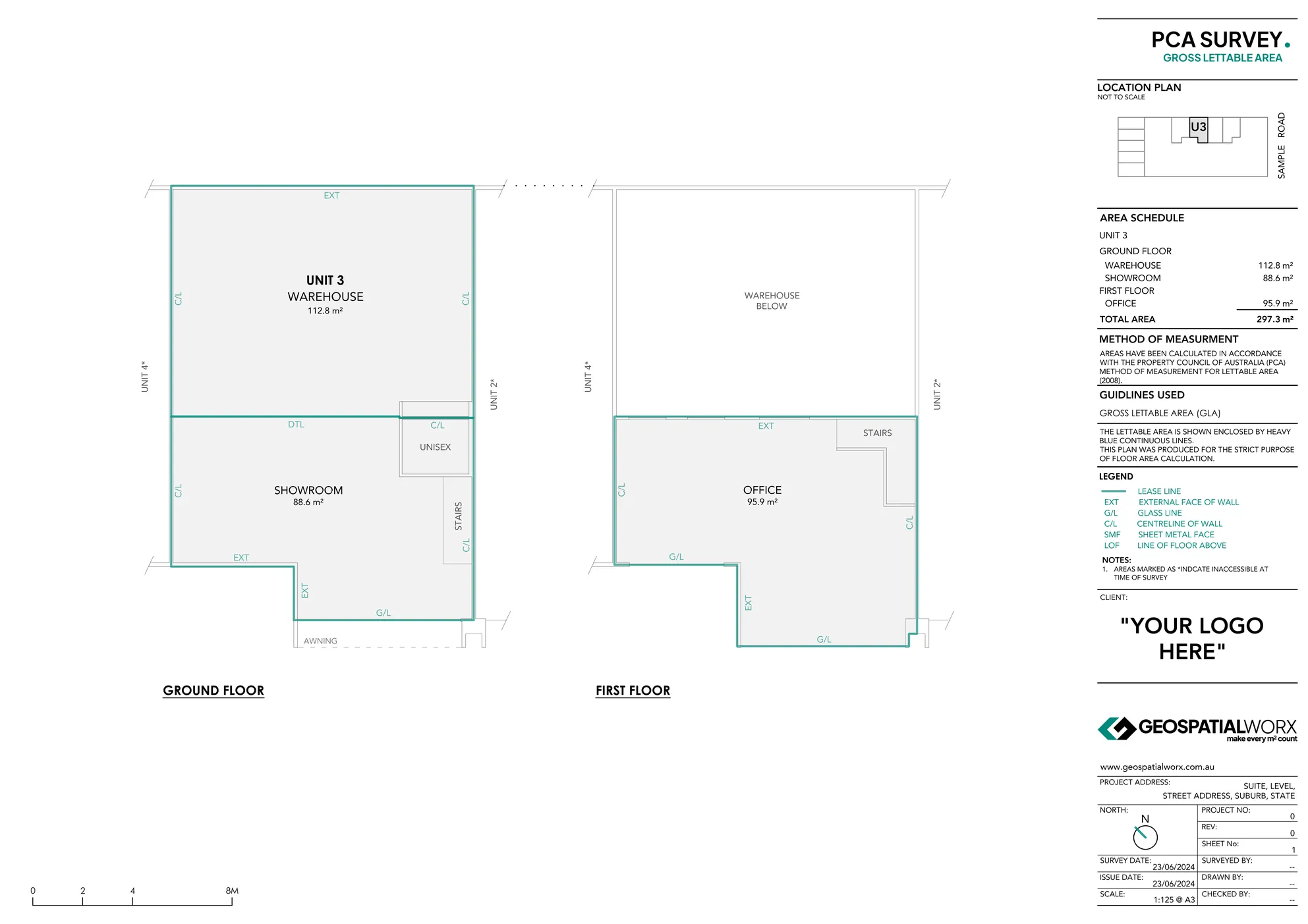
Gross Lettable Area Survey (GLA)
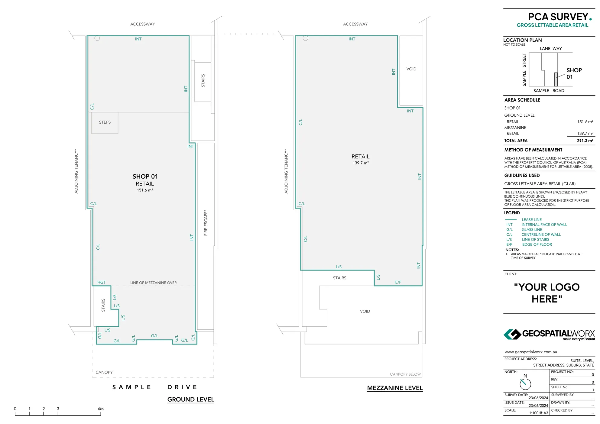
Gross Lettable Area Retail Survey (GLAR)
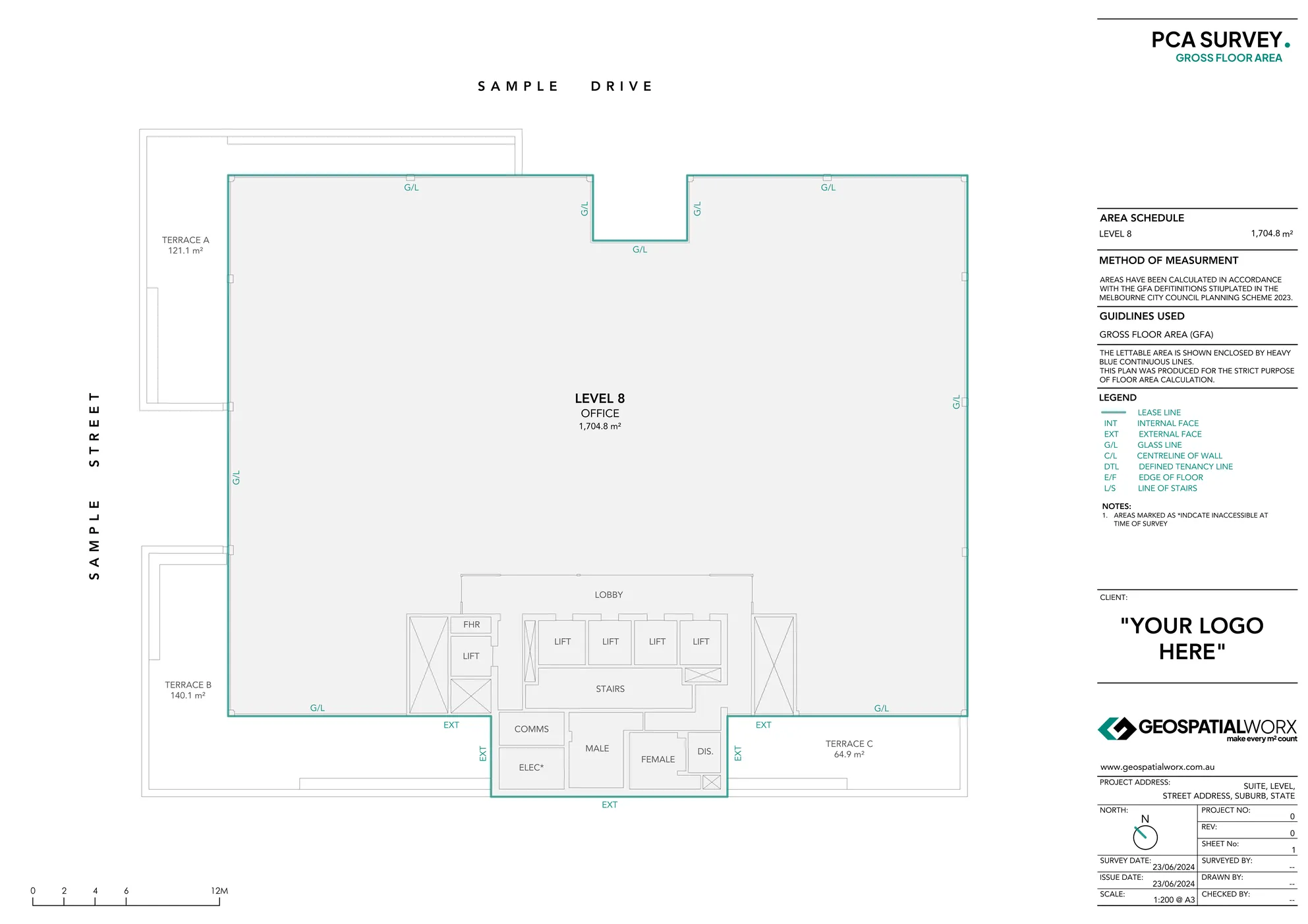
Gross Floor Area Survey (GFA)
Not Sure Which Survey You Need?
Reach out to the team directly and we’re happy to help.
PCA Surveys for Leasing Accuracy and Compliance
At GeospatialWorx, our PCA Surveys are carried out in strict accordance with the Property Council of Australia’s (PCA) Method of Measurement — the national standard for defining and reporting lettable areas. Designed for leasing, asset management, and property valuation, these surveys provide landlords, tenants, and property managers with accurate, audit-ready documentation that makes every m² count.
What Are PCA Surveys?
A PCA Survey measures and documents the lettable areas of commercial, industrial, retail or residential properties in line with the Property Council of Australia’s guidelines. This ensures all parties involved in a lease agreement — landlords, tenants, agents, and valuers — are working from the same verified, compliant data.
Our team delivers high-precision PCA Surveys that identify and calculate areas such as Net Lettable Area (NLA), Gross Lettable Area (GLA), Gross Lettable Area Retail (GLAR) and Gross Floor Area (GFA) with complete accuracy and consistency.
Why Use PCA Surveys?
- Leasing Accuracy – Define and report lettable areas with confidence.
- National Compliance – Fully aligned with PCA’s Method of Measurement.
- Audit-Ready Deliverables – Clear documentation suitable for inclusion in legal leases and valuation reports.
- Risk Reduction – Avoid costly disputes caused by inconsistent or outdated area data.
- Trusted by Professionals – Used by landlords, agents, valuers, and asset managers across Australia.
Our Process
1. Site Measurement
We capture building data using advanced 3D laser scanners or total stations to ensure millimetre precision.
2. Plan Drafting & Area Calculation
Basic floor plan is then drafted up allowing lettable areas to be calculated and categorised under PCA definitions such as NLA, GLA, GLAR, or GFA.
3. Verification & Compliance
Each survey is reviewed to confirm alignment with PCA standards and client-specific requirements.
4. Delivery
Final deliverables are supplied in PDF including a basic floor plan, lease line nominations and an area schedule with a statement of compliance to the PCA.
Made for
- Landlords and Asset Managers – Validate building areas for leasing and valuation.
- Leasing Agents – Ensure lettable areas are compliant and transparent.
- Valuers and Consultants – Access consistent, verified data for financial reporting.
- Tenants - Rents, outgoings, and market reviews are calculated per square metre. A PCA-compliant survey gives you certainty on the area you're paying for-potentially saving you real money.
Technology We Use
- Leica 3D Laser Scanners for surveying
- Topcon Total Stations for surveying
- BricsCAD for drafting
Deliverables - Report Inclusions
- PCA-Compliant Floor Plan
- Area Summary Tables (sqm and breakdowns)
- Identification of lease boundaries and their definitions
- Statement of PCA compliance
Every GeospatialWorx PCA survey includes more than just a number — we deliver clear, styled plans with transparent lease boundaries and all relevant area data
Not Sure Which Survey You Need?
Reach out to the team directly and we’re happy to help.
Frequently Asked Questions
When would i need a PCA Survey?
Typical triggers can include new leases, lease renewals, rent reviews, make-good assessments, valuations, du-diligence, re-planning and when fitouts or base-building works may have changed an area.
What will I receive when I order a PCA Survey?
You will receive PCA compliant PDF report in A3 format. The report itself will contain a basic base building floor plan identifying all area types. Lease lines and their subsequent nominations are shown along with an area schedule and a statement of compliance to the PCA.
How accurate are the results on a PCA Survey?
Site measurements are taken to high precision; reported areas follow PCA rounding conventions tot he first decimal place. Any constraints or asumptions are documented in the report.
What access do you need and will the survey interrupt operations?
Access into all internal areas is generally required. Field-work is non-intrusive. 3D Scanners and total stations are tripod mounted, and typical tenancy captures are completed quickly to next to no impact on staff or customers.
What if the tenancy or building undergoes a fitout?
Any change that alters the shape/configuration of an internal space can affect lettable area. We can resurvey the affected zones and issue an update PCA Survey.
What is an IPMS Survey and how is it different to a PCA Survey?
IPMS (International Property Measurement Standards) is a global framework designed to make property measurements comparable across countries. For offices, for example, you’ll see IPMS 1, IPMS 2, IPMS 3 (capturing different levels of detail from whole-building to occupant areas). IPMS also exists for industrial, residential, and retail.
- Where it differs: PCA is Australia-specific and optimized for local leasing and valuation (NLA/GLA/GLAR and PCA inclusion/exclusion rules). IPMS uses its own definitions and calculation tiers, so IPMS results will often differ from PCA for the same space.
- When to use: Choose IPMS for cross-border reporting or global portfolio consistency; choose PCA for Australian leasing, valuation, and compliance. We can deliver both sets of figures from a single survey if required.
What is a BOMA Survey and how is it different to a PCA Survey?
BOMA (Building Owners & Managers Association) standards are commonly used in North America. They define areas such as Rentable Area and Usable Area and set rules for how shared spaces (e.g., corridors, lobbies) are apportioned to tenancies.
- Where it differs: PCA (Property Council of Australia) sets NLA/GLA/GLAR rules for Australian leases and valuations. BOMA uses different terminology and boundary rules (e.g., how to treat common areas, wall thickness, and projections), so figures from BOMA and PCA are not interchangeable.
- When to use: If your portfolio or lease documents are aligned to Australian practice, use PCA. If you’re reporting to North American stakeholders or BOMA-based leases, request BOMA. We can produce either—and map one to the other when needed.
Wasn't there are BOMA Australia Method of Measurement which pre-dated the PCA?
Yes. Australia used a BOMA (Australia) Method of Measurement before the PCA standard. The Property Council of Australia (PCA) introduced its own Method of Measurement for Lettable Area in the late 1990s (commonly cited as 1997), which superseded the earlier BOMA (Australia) guidance. Many legacy leases still reference “BOMA,” so it’s not unsual to see either terms in older documents.
Compliant
Experience
Experience
Expertise