
Gross Floor Area (GFA) Survey
We capture total building floor area for development assessments, applying the relevant council/state GFA definition with precision & certainty.
Made for Planning and Development

Get Your GFA Survey Today
Reach out to the team directly and we’re happy to help.
Gross Floor Area (GFA) Surveys for Planning, Design, and Valuation
At GeospatialWorx, we calculate the total enclosed floor space used for planning and development controls (e.g., plot ratio/FSR). Measurements are completed to the relevant council or state definition (often the external face of perimeter walls, unless otherwise specified) and supplied with clear notes on inclusions/exclusions.
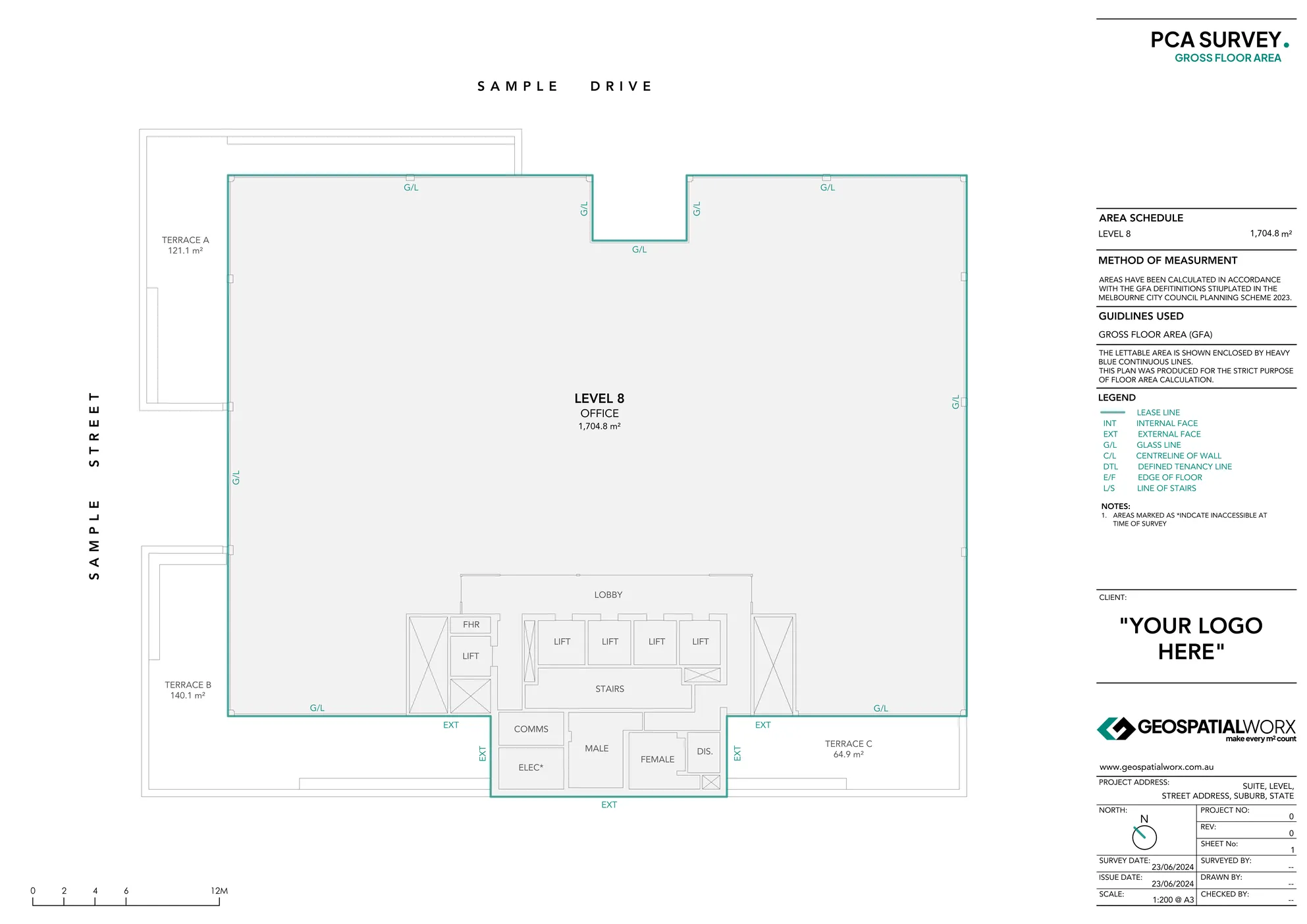
What Is a GFA Survey?
A GFA survey sums the enclosed areas of a building’s floors within the planning envelope, then applies the specific inclusions/exclusions required by the applicable planning scheme. Depending on jurisdiction, this can include or exclude elements such as lobbies, vertical circulation, plant areas, certain basements, awnings, and balconies. We confirm the governing definition up-front and apply it consistently across the site.
Why Use GFA Surveys?
- Planning compliance – Align DA/CDC submissions with correct local GFA rules.
- De-risking & clarity – Reduce objections and re-work caused by inconsistent area data.
- Development yield – Support site coverage, FSR/plot ratio and feasability assessments.
- Valuation & reporting – Provide consistent, verified figures for reports and advice.
Our Process
1. Site Survey & Data Capture
We use high-accuracy Leica 3D scanners or total stations to record the full extent of a building’s internal and external envelope.
2. Area Drafting & Calculation
Data is processed allowing drafting of plan and subsequent areas which are then tabulated to the adopted definition; calculations are repeatable and fully traceable.
3. Verification & Compliance Review
Internal QA checks alignment with the scheme, client specific requirements, and any referenced standards.
4. Delivery
A PDF report (A3) with the GFA plan(s), area schedule, and a method starement (definition + inclusions/exclusions).
Made for
- Developers & Architects – Reliable GFA data to support DA/CDC submissions, feasability and design co-ordination.
- Town Planners – Verified calculations against the relevant council/LEP definition; clear inclusions/exclusions for FSR/plot ratio.
- Valuers & Asset Managers – Consistent, certified measurements for reporting and portfolio comparables.
Technology We Use
- Leica 3D Laser Scanners
- Topcon Total Stations
- BricsCAD / AutoCAD
Deliverables: Report Inclusions
- GFA plan set (PDF, A3) - colour coded drawings with clear labelling
- Area schedule (m²) — per floor/building, with FSR/plot-ratio summary (where applicable)
- Method statement — governing definition + inclusions/exclusions and any assumptions
GeospatialWorx delivers GFA surveys that bring consistency, transparency, and compliance to planning and valuation — ensuring every m² is counted with confidence.
Get Your GFA Survey Today
Reach out to the team directly and we’re happy to help.
Frequently Asked Questions
What is a GFA Survey used for?
Planning approvals and FSR/plot-ratio checks—measuring building bulk to the governing council definition.
Does the definition change by council?
Yes. We apply the exact LEP/DCP/Planning Scheme rules and cite them in the report.
What is a general defintion of GFA (Gross Floor Area)?
For example citing the City of Melbourne's Planning Scheme (under Clause 73.01): "The total floor area of a building, measured from the outside of external walls or the centre of party walls, and includes all roofed areas."
How is GFA different from NLA/GLA/GLAR?
GFA = planning metric; NLA/GLA/GLAR = leasing areas. Use GFA for DA/CDC, the others for rent/outgoings.
How are balconies, court yards and canopies treated?
External areas open to the environment such as these are typically excluded from GFA and listed seperately.
What is a GBA (Gross Building Area) Survey and how is it different to a GFA Survey?
GBA (Gross Building Area) is the sum of all fully enclosed internal spaces and unenclosed external spaces - also measured from the external face of perimeter walls. The difference between the two is that external areas such as balconies, court yards and canopies are permitted under GBA.
Compliant
Experience
Experience
Expertise